WDSS-II: Frequently Answered Questions
Please read the overview documentation first. These are questions that are not answered in the overview documentation.When I run the WDSS-II programs, I get an "Authorization for w2api expired" message. How do I fix this?
Download and install the "authorization extension" from the "Obtaining WDSS-II" section of this website.
Is WDSS-II open-source? Is it free?
WDSS-II is free for research (non-commercial) use, but is not open-source. For commercial use, the software is licensed by the University of Oklahoma.
What are pixel_x and pixel_y in the netcdf files produced by WDSS-II?
By default, WDSS-II run-length encodes its netcdf files because netcdf has no built-in compression mechanism. See the description of the data format in the section marked "Data Format" for more details.
If you are writing relatively small files, or if the I/O performance is not important to you, you can turn this feature off. Edit w2config/misc/dataformat and change the sparsegrid setting to "never". You will then get traditional two-dimensional variables.
What platforms is WDSS-II supported on?
WDSS-II works on Linux kernels 2.4 and higher (Fedora Core 2 and 3. Red Hat Enterprise 3 and 4). It has been built on both 32-bit and 64-bit systems. The display alone works on Windows, but this is experimental at present.
What kind of hardware do I need to run WDSS-II?
Depends on what you want to do.
What kinds of data can I process with WDSS-II?
Any polar data, lat-lon grids and spatially-located tabular data. If you can put the data in the netcdf format for grids or the XML format for tables, we can read it and process it. Ingest programs already exist in the WDSS-II software distribution for Level-II NEXRAD data, TDWR data, NLDN lightning and LMA source data and RUC2 grib files. Data from SMART-R, CASA, GOES satellite and KOUN dual-pol have been converted into WDSS-II netcdf's format by other people. WDSS-II natively reads Level-III data (by setting the W2_EXTENSION_LIBS environment variable to include w2nexrad). We encourage you to donate your ingest code (the software that converts some other format to netCDF) to the WDSS-II package.
How can I add background maps to the WDSS-II display?
Follow the instructions on the forum.
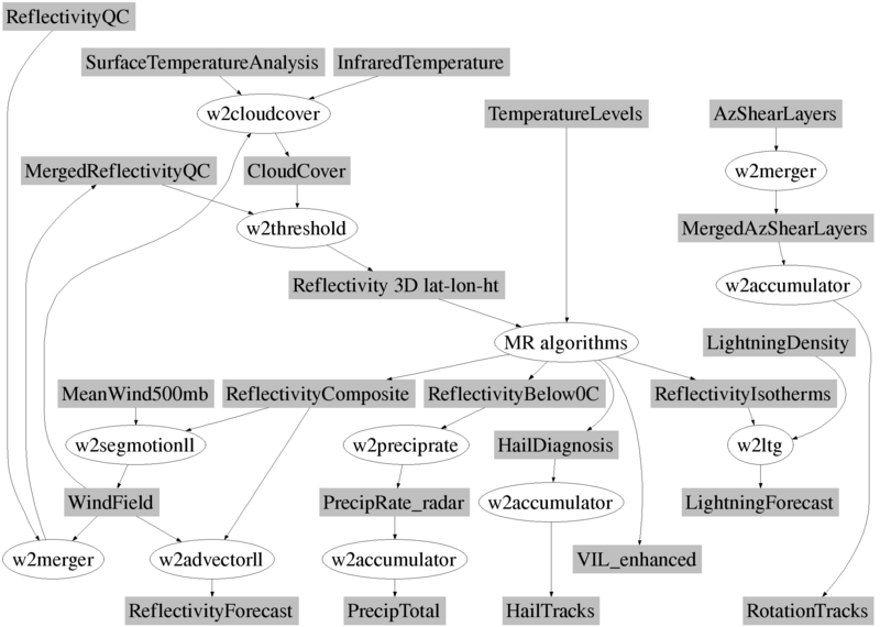
Your list of tools is too long. What are really the most commonly used tools?
The most commonly used severe weather algorithms are shown in these schematics, for single radar algorithms and multi radar algorithms . The most commonly used lower-level tools are:
- the scoring program w2scoregrid which can be used to compare two grids in a statistical sense.
- the tracking program w2segmotionll which can be used to track storms and compute storm statistics
- the polygon statistics program w2alarm
- the objective analysis program w2oban
- the smoothing program w2smooth
- the spatial erosion/dilation program w2morph